 EMODnet Product Catalogue
Mineral resources
Type of resources
Available actions
Topics
Keywords
Contact for the resource
Provided by
Years
Formats
Representation types
-
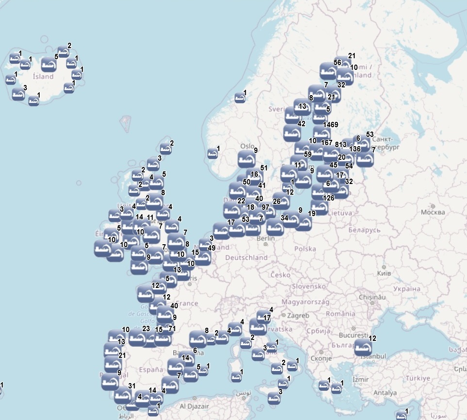
The dataset on dredging in the European waters was created in 2014 by AZTI for the European Marine Observation and Data Network (EMODnet). It is the result of the aggregation and harmonization of datasets provided by several sources from all across the European countries. It is available for viewing and download on EMODnet web portal (Human Activities, https://emodnet.ec.europa.eu/en/human-activities). The dataset contains points representing dredging sites in the following countries: Belgium, Bulgaria, Cyprus, Denmark, Estonia, Finland, France, Germany, Greece, Iceland, Ireland, Italy, Latvia, Lithuania, Malta, Norway, Poland, Portugal, Spain, Sweden, The Netherlands and United Kingdom. Where available, each point has the following attributes: Id (Identifier), Position Information (e.g.: Estimated, Original, Polygon centroid of dredging area, Polygon centroid of dredging polygon), Country, Sea basin, Sea, Extraction Area, Year (when data is for a time period, the first year of the period is indicated), Permitted Amount (m3), Permitted Amount (t), Extracted Amount (m3), Extracted Amount (t), Extraction Type (e.g.: Harbour dredging, Estuary dredging, Sea lane), Purpose (e.g.: Maintenance dredging, Capital dredging, Others), End Use (e.g.: Beach nourishment, Commercialization, Confined deposit, Construction material, Embankment, Filling material, Land deposit, Reuse, Sea disposal, Wetland restoration), Material type (e.g.: silt, sand, gravel), Notes, Link to Web Sources.In the 2023 update, extraction data until 2022 has been included.
-
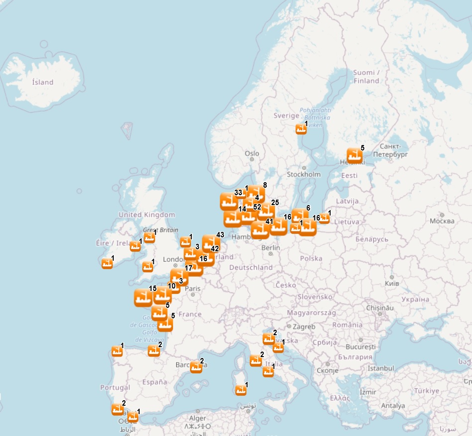
The dataset on aggregate extractions in the European seas was created in 2014 by AZTI for the European Marine Observation and Data Network (EMODnet). It is the result of the aggregation and harmonization of datasets provided by several sources from all across the EU. It is available for viewing and download on EMODnet web portal (Human Activities, https://emodnet.ec.europa.eu/en/human-activities). The dataset contains points representing aggregate extraction sites, by year (although some data are indicated by a period of years), in the following countries: Belgium, Denmark, Finland, France, Germany, Ireland, Italy, Lithuania, Poland, Portugal, Spain, Sweden, The Netherlands and United Kingdom. Where available, each point has the following attributes: Id (Identifier), Position Info (e.g.: Estimated, Original, Polygon centroid of dredging area, Estimated polygon centroid of dredging area), Country, Sea basin, Sea, Name of the extraction area, Area of activity (km2), Year (the year when the extraction took place; when a time period is available, the first year of the period is indicated), Permitted Amount (m3) (permitted amount of material to be extracted, in m3), Permitted Amount (t) (permitted amount of material to be extracted, in tonnes), Requested Amount (m3) (requested amount of material to be extracted, in m3), Requested Amount (t) (requested amount of material to be extracted, in tonnes), Extracted Amount (m3) (extracted amount of material, in m3), Extracted Amount (t) (extracted amount of material, in tonnes), Extraction Type (Marine sediment extraction), Purpose (e.g.: Commercial, Others, N/A), End Use (e.g.: Beach nourishment, Construction, Reclamation fill, N/A), Material type (e.g.: sand, gravel, maerl), Notes, Link to Web Sources. In 2018, a feature on areas for aggregate extractions was included. It contains polygons representing areas of seabed licensed for exploration or extraction of aggregates, in the following countries: Belgium, Denmark, Estonia, Finland, France, Germany, Italy, Lithuania, Poland, Portugal, Russia, Spain, Sweden, The Netherlands and United Kingdom. Where available, each polygon has the following attributes: Id (Identifier), Area code, Area name, Country, Sea basin, Sea, Starting year (the year when the license starts), End year (the year when the license ends), Site Type (exploration area, extraction area, extraction area (in use)), License status (Active, not active, expired, unknown), Material type (e.g.: sand, gravel, maerl), Notes, Distance to coast (in metres), Link to Web Sources. In the 2023 update, extraction data until 2022 and new areas have been included.